Winterville Mounds
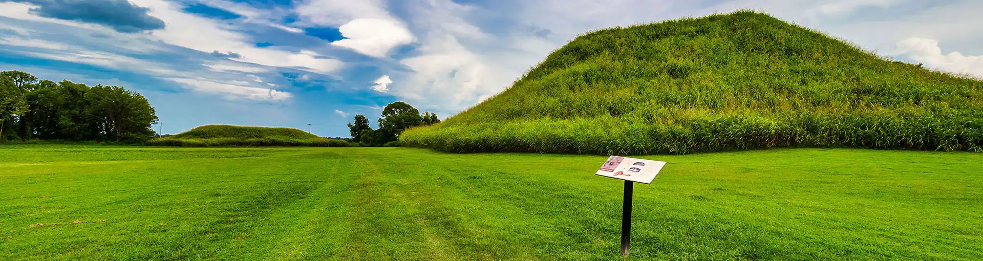
For more than a thousand years, travelers have visited the communal gathering space at Winterville Mounds, one of the largest Native American mound sites in the United States. The mounds at Winterville were hand built by people that thrived in this area from about AD 1000 to 1450. Winterville served as a communal space- not just ceremonial, but a place to gather, trade, and celebrate. Twelve of the original 23 mounds and two large plazas are still intact today. Since 2000 the Mississippi Department of Archives and History has administered this significant cultural site. MDAH actively engages in consultation with the federally recognized Native American Tribes with ancestral ties to Mississippi. We ask that visitors conduct themselves respectfully while in this sacred place and that you do not walk on any of the mounds.

Artist reconstruction of Winterville Mounds circa 1250
About
Archaeological evidence indicates that the Native Americans who used the Winterville Mounds were most likely ancestral to the Natchez people, a tribe documented by French explorers and settlers in the early 1700s near the modern-day city that bears their name. The primary accounts written by these colonists, including Natchez lifestyles and the activities that happened at their ceremonial mound centers, lead many scholars to label them as the “last of mound builders” and “last of the Mississippian chiefdom.”
Mound building was a community activity. As such, massive amounts of labor were needed to construct these mounds, plazas, and other earthworks. All of the work was done by hand- community members dug the soil and loaded it into baskets, then carried the baskets to the site, dumped it out, and tamped it down. This process was repeated until the desired shape and height of the mound was reached. Over the years, each mound was enlarged several times after its initial construction using this method. Mound maintenance would have been an important part of community life, and the mounds would have looked much different than the grassy hills seen today. Evidence recovered during archaeological investigations in 2016-2017 indicates that Mound A was covered with clay, which would have kept the summit clean and prevented erosion.
It seems to have been common practice to burn any structure at its summit before enlarging a mound and then building another structure when new construction was completed. These sites served as community centers with temples and houses for chiefs placed atop the mounds. The civic and religious leaders, often ordained through matrilineal kinship, lived at these mound sites while most of the population lived at family farmsteads dispersed across the area. People from the surrounding areas would travel to and congregate at the site for special events, feasts, and ceremonial activities.
A great fire during the late 1300s consumed the original building on the Temple Mound (Mound A) at Winterville, according to archaeological evidence. The cause of the fire remains a mystery. The site continued to be used afterwards, but no more mounds were built or maintained. While the site continued to be occupied after the fire, the general population declined at Winterville while increasing at settlements and mound sites 50 miles to the south, in the lower Yazoo River basin. By AD 1450, Winterville Mounds appears to have been abandoned completely.
To learn more about Winterville Mounds, download Archaeological Report No. 23.
Reconstruction of Mound A


At 55 feet, Mound A is among the ten tallest earthen structures in the United States. This platform-type mound is often called a Temple Mound because it would have supported a structure serving as a space for religious ceremonies. Mound A also provided a vantage point from which to view the entire site and surrounding area, including the Mississippi River approximately one mile to the west at the time mound construction began.
Since Winterville was an active plantation and later a tenant farm, agricultural practices such as plowing and livestock grazing severely affected the site prior to its conversion to a state park. By the early 1930’s, Mound A’s size had been reduced significantly, and the ramp had been almost completely erased. Fearing for its future, the Greenville Garden Club raised funding to purchase the 42—acre tract, and then donated the land to the State Park commission (now Wildlife, Fisheries, and Parks) in 1960. An original effort to repair the erosion was completed in 1968.
Since 2016, heavy rainfall, wind, and tornadoes have periodically caused significant erosion to Mound A. In 2021, the Mississippi Department of Archives and History (MDAH), in collaboration with FEMA and the MDAH federally recognized Tribal partners, began an effort to stabilize the mound and restore it to its original condition. This collaboration undertook many phases of design, engineering, and review to ensure it met the needs of all parties. This included a variety of investigation methods for both the mound and surrounding plaza to ensure no harm came to archaeological resources during construction. For example, prior to defining the construction area limits, MDAH had ground-penetrating radar performed around the mound to detect any subsurface structures. Additionally, MDAH archaeology staff completed limited testing of the mound fill with small soil probes to determine the thickness of the 1968 fill.
Both of these methods allowed MDAH, FEMA, and Tribes to work with an engineer to develop a methodology that protected the original mound fill. Construction crews removed only the top few inches of sod to provide a clean surface, and then sterile fill was placed around that surface, similar to putting on a protective coat. Construction included recreation of the ramp, although regulations necessitated it being slightly larger than its original design. Final construction phases included removal of protective matting that was placed to prevent damage to the surrounding plaza and was completed in October 2024.
Additional Mounds at Winterville

Map of Winterville Mounds from 1860
Although Mound A is certainly the most prominent, originally Winterville contained at least 22 additional mounds according to available maps and personal accounts. Many of these were located in the agricultural fields surrounding the site and have been lost to erosion and agricultural practices. However, several of the original mounds were saved and are being preserved.
At about 30 feet high, Mound B is the second-tallest mound at Winterville and sits at the southwest end of the mound group. It has also proven to be one of the richest sources for information over the last hundred years. It was constructed in multiple stages and exhibits evidence of burned structures. Mound B was connected to many of the other mounds via a causeway, which is simply a raised walkway.
Mound C forms an oval shape in layout, rather than the more commonly found round or quadrilateral shape. The mound’s present shape is due to slumping and erosion. The discovery of a trash pile, called a midden, and structural remains including wall trenches with repeated burning points to its usage through Winterville’s history.
Mound D sits along the western border of the site and was constructed on an earlier, pre-mound occupation deposit dating to the end of the Coles Creek period (AD 1000–1200). In 2007, University of Southern Mississippi excavations uncovered a trash-filled pit near Mound D containing layers of animal bone (squirrel, rabbit, waterfowl, and other birds) and broken pottery that date to ca. AD 1200. The pit may have been excavated to provide materials to form Mound D, and the layers of trash may represent feasts associated with its construction.
Mound F functioned as a platform for a structure, likely a house. Excavations in 1967-1968 indicate that it was constructed in a single event rather than over time. Recent archaeological discoveries about the history of Winterville Mounds include the confirmation that a causeway existed between Mound A and F, originally depicted in a map of the site from 1860. Causeways have been identified between other mounds at Winterville, but Mound F appears to be significant as it is the only one connected to the Temple Mound.
Mound E has been largely lost to erosion but is barely visible on the landscape. Additionally, Mounds G, H, I, and J are heavily eroded, with Mounds I and J barely visible along the property line. Little archaeological work has been completed on these mounds, but 1969 work by Jeffrey Brain on Mound G has indicated that this mound played a role in mortuary practices at Winterville.
There is archaeological evidence that structures were present on Mound K at different times. It was common to burn one structure, add to the earthen mound, and build another structure on the newly made surface. Few artifacts were found which suggests that the first structure was purposefully cleared prior to being destroyed. Finally, Mound L has been greatly impacted by agricultural practices and is slightly visible on the southern property line.
In addition to the mounds, the plazas also played a key role in the Winterville site. A plaza, in archaeology terms, is simply an empty area between mounds or mound groupings. Winterville is considered to have two main plazas, the space between Mounds A and B, and the exterior area outside Mounds F-I. Excavations by the University of Southern Mississippi revealed that this second plaza contained a sizeable midden and evidence of feasting, indicating a thriving seasonal population visited this significant site.
Hours
Sunday–Saturday
Dawn to dusk.
Grounds only.
Find Us
2415 Highway 1 North
Greenville, MS 38703
Info@wintervillemounds.com
662-334-4684